
Baja California Sur, lit. "Lower California South", officially Free and Sovereign State of Baja California Sur (Spanish: Estado Libre y Soberano de Baja California Sur), is the second smallest Mexican state by population and the 31st admitted state of the 31 states which, with the Federal District, make up the 32 Federal Entities of Mexico.
.gif)
Before becoming a state on October 8, 1974, the area was known as the South Territory of Baja California (El Territorio Sur de Baja California). It has an area of 73,475 km2 (28,369 sq mi), or 3.57% of the land mass of Mexico, and occupies the southern half of the Baja California peninsula, south of the 28th parallel, plus the uninhabited Rocas Alijos in the Pacific Ocean. It is bordered to the north by the state of Baja California, to the west by the Pacific Ocean, and to the east by the Gulf of California, also known as the "Sea of Cortés". The state has maritime borders with Sonora and Sinaloa to the east, across the Gulf of California.
The state is home to the tourist resorts of Cabo San Lucas and San José del Cabo. Its largest city and capital is La Paz.
Geography and environment Political geography The state is the southern part of the Baja California peninsula, located in the northwest of Mexico. With a territory of 73,909 km2, it is about 750 km long and averages about 100 km wide. The state is divided into five municipalities. Comondú is located in the center of the state with its seat at Ciudad Constitución. It borders the municipalities of Mulegé, Loreto and La Paz with the Pacific Ocean to the west. Mulegé is in the north of the state with its capital in Santa Rosalía, with two other important population centers at Guerrero Negro and Mulegé. It borders the municipalities of Comondú and Loreto with Baja California Norte to the north, the Pacific Ocean to the west and the Gulf of California to the east. It accounts for almost 45% of the state’s territory. The municipality of La Paz is in the south of the state. It is the second largest municipality, accounting for just over 27% of the territory of the state. It borders the municipalities of Comondú and Los Cabos and extends from the Pacific Ocean to the Gulf of California.The municipality of Los Cabos is at the southern tip of the state, with its seat at San José del Cabo and its most populous city is Cabo San Lucas. The municipality is one of the most important tourist destinations in Mexico. The municipality borders that of La Paz to the north, with the rest defined by the Pacific Ocean and Gulf of California. The municipality of Loreto is located in the center of the state, with the city of Loreto as its seat. It borders the municipalities of Mulegé and Comondú with the Gulf of California to the east. Its major cities are La Paz (219,596) San Jose del Cabo (164,162) Ciudad Constitución (63,830) Santa Rosalia (52,743) Loreto (11,839) . Other important cities include: Ciudad Insurgentes, Comondú Municipality Guerrero Negro, Mulegé Municipality Loreto, Loreto Municipality El Pescadero, La Paz Municipality Todos Santos, La Paz Municipality
Natural geography

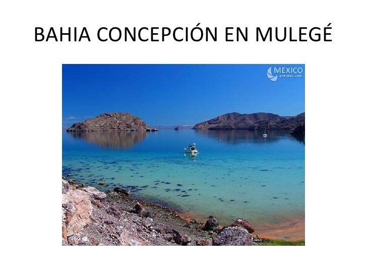
The arch at Land's End, Cabo San Lucas The state is on a narrow peninsula which broke away from the mainland about two million years ago because of tectonic activity. The territory is primarily mountains or mountain ranges and coastal plains. The mountain ranges parallel the coastline and are of volcanic rock with an average altitude of 600 meters above sea level. The local name for the main mountain range is the Sierra de la Gigante and the highest peak is the Sierra de la Laguna at 2080 meters above sea level. The coastal plains are significantly wider on the Pacific side than the Gulf of California side, with those on the Pacific side averaging a width of about forty, with much wider plains such as those of Santa Clara, Berrendo and Magdalena y Hiray. These areas are dominated by sedimentary rock, especially limestone of marine origin. The state is divided into five regions: Central Desert, La Serranía, the Vizcaíno Desert, the Magdalena Plains and Los Cabos. The Central Desert has desert plants and the only green appears during short and irregular rains. The La Serranía is the high mountain areas with tree species, a number of which are commercially valuable. The Vizcaíno Desert runs along the Pacific coast around the Ojo de Liebre and San Ignacio lagoons and contains lower mountain ranges such as the San Francisco, San Alberto, Las Tinajas de Murillo and El Serrucho, along with the El Azufre and Las Vírgenes volcanos. The Magdalena Plains is a large, flat area near the Pacific coast, and the Los Cabos region is distinguished by microclimates determined by the geologic change in the area and rain patterns. The climate of the state is dry, with an average annual temperature between 18 and 22C and average annual rainfall of less than 200mm. The lower elevations are the driest and hottest, with temperatures climbing as high as over 40C in the summer. The winters can see lows of below freezing. The exception to desert conditions is the Los Cabos region, classified as semi-moist because of Pacific hurricane activity affects the region. In the spring, prevailing winds are from the west and in the summer from the south and southwest. In the fall, they are from the northwest and in the winter from the north and northwest. View of the San Jose Estuary Most of the surface water on land is in the form of seasonal streams, which are fast flowing and only active during rains. Most of these empty into the Pacific Ocean with a number flowing south into the Bahía de Ballenas. The main geological feature of the state is its coastline which measures 2230 km, making it Mexico’s longest with 22% of the total. It also has the most islands, mostly in the Gulf of California. There are three in the Pacific, Natividad, Magdalena and Santa Margarita (the largest). In the Gulf of California they include San Marcos, Coronasos, Carmen, Monserrat, Santa Catalina, Santa Cruz, San Diego, San Jose, San Francisco, Partida, Espiritu Santo and Cerralvo. Major bays include Sebastian Vizcaino, Magdalena, La Paz, Asunción, Ballenas, Concepcion and San Carlos. Estuaries and lagoons including those at Puerto Escondido, Nopoló, Blandra as well as the San José estuary at Cabo Colorado, the San Ignacio Lagoon and the Ojo de Liebre.
The ecological system here is considered to be recently evolved with a number of endemic species. The lower elevations are dominated by desert and arid condition plants. This includes the world’s largest species of cactus, the cardón cactus, which can reach heights of 21 meters. Other plant species include mesquite, chironola, lechuguilla, nopal and barrel cactus, choyas, paloadan and pitahaya. The higher elevations have forests of pine and holm oak with some deciduous forests, with leaves falling in the dry season, generally no taller than fifteen meters.[18] Wildlife in the desert areas is restricted to birds, reptiles and small to medium mammals such as rabbits and coyotes. Upper elevations with more vegetation can have wild rams, pumas, other wild cats, raccoons, deer, foxes and wild cats. Marine species include whales, seals, dolphins, gray whales, manta rays and sea turtles. National parks and other protected areas include the Sebastian Vizcaino Bay, the San Ignacio Lagoon, the Sierra la Laguna, Laguna Ojo de Liebre and the islands in the Gulf of California.
Port of Cabo San Lucas Traditionally based mostly on tourism, sport fishing, salt production and mining, in 2012 the GDP of the state accounted for only .73% of the country’s GDP, but grew 3.13% in comparison to the year prior. In 2013, this growth increased to 7.8%. Unemployment in 2013 was 5.1% with employment shifting away from agriculture and fishing to mining and industry (up 19.9%) and commerce (up 4.9%). Today, agriculture, fishing and forestry account for only 3.89% of the state GDP. Commercial species include tuna, sardines, anchovies, clams, snails, oysters, shark, lobsters, abalone, shrimp and crabs, which are sold both nationally and internationally. Commercial fishing harvests lobster, shrimp, tuna, abalone and clams. Major crops include garbanzo beans, sorghum, tomatoes, alfalfa, wheat, corn and green chili peppers. Livestock includes pigs, cattle, goats and chickens. Mining, construction and utilities account for 26.61%. Mining includes plaster (mainly on the San Marcos Island), limestone (in Todos los Santos), phosphorus (in San Juan de La Costa and Adolfo LópezMateos, Comondú), copper (en Santa Rosalía), gold and silver (in the Triunfo-San Antonio mine), manganese (in Santa Rosalia and Punta Concepción Bay) and chrome (in San SebastiánVizcaíno and Magdalena bays). There are other minerals not yet routinely mined such as titanium, tungsten and cobalt. There is some possibility of offshore hydrocarbons. The state also produces salt of 99.7% purity, mostly in the area around Guerrero Negro. There are two major industrial/technology parks: Parque Tecnológico BioHelis and Parque Industrial La Paz Sur. Traditional handcrafts can be found throughout the state and include articles made with seashells, palo chino, choya and cardon cactus. Baskets and other items are woven from palm fronds especially in el Triunfo Los Planes and the Sierra de los Dolores as well as fishing nets. Another important craft is leatherwork, especially the making of gear for horseback riding such as saddles, holsters and chaps along with belts and carrying bags. In addition, scrap metal is converted into various types of knives. Royal Solaris resort in San Jose del Cabo Commerce and services account for 69.5% of the GDP. La Paz was ranked 31st in Mexico by the World Bank and the Corporación Financiera Internacional in ease of doing business and 23rd as a place to open a business. Major activities of this type include hotel and food service (16.43%) and housing sales and rentals (10.67%), which along with other activities (17.65%) account for 58.37% of the total GDP. The most dynamic aspect of the economy is tourism, with a number of natural resources which are apt for this purpose, such as the grey whales that come to the area to breed and the natural rock arch at Land’s End is frequently photographed. Tourist attractions are divided into three regions: north (Guerrero Negro to Ciudad Constitución), center (La Paz to Todos Santos) and south (Los Barriles to Cabo San Lucas) . There are two main resort areas, Cabo San Lucas and San Juan del Cabo, both in the southern tip of the peninsula. A highway known as the Corridor links the two towns. Other attractions include deep sea fishing, golf, tennis, motorcycling, scuba diving and snorkeling, with windsurfing at Medano Beach and surfing at Todos Santos, Pescadero East Cape and Scorpion Bay. Other important activities include fishing and fish farming, alternative energy production, mineral and salt extraction, film production, information and communication technologies and biotechnology.
Infrastructure As of 2011, the state has 5,651 km of highway, eleven ports, five of which are international and four international airports. The peninsula's main transport artery is Mexican Federal Highway 1, which runs from the southern end of the peninsula at Cabo San Lucas to the United States-Mexico border at San Ysidro. Mexican Federal Highway 19 provides an alternate route between Cabo San Lucas and La Paz. There are also ferries from the east coast of the peninsula to the mainland, with most going to Mazatlán in the state of Sinaloa. This trip takes about five hours. The state's main airports are Los Cabos International Airport and Manuel Márquez de León International Airport.
History One of the historical murals in the municipal hall of San Jose del Cabo
Name The state is named after the peninsula on which it is found, Baja (Lower) California, with the term “Sur” meaning “south.” The name California applied to this peninsula along with the area now known as the state of California in the United States, and came from the name of an island from European myth. The coat of arms emphasizes the state’s connection to the sea, including images of silver fish, a silver shell and a blue background.
BAJA CALIFORNIA SUR TODAY Tourism, sport fishing, agriculture and salt mining make the biggest contributions to the state`s economy. Salt is mined from the ocean and sold as table salt or a preservative. Major crops include garbanzo beans, sorghum, tomatoes, alfalfa, wheat, corn and green chilies. Ranchers raise pigs, cattle, goats and chickens. The state’s extensive coastline ensures plentiful harvests of seafood such as lobster, shrimp, tuna, abalone and clams. Local bands traditionally play an accordion and two guitars, interpreting rhythms like corridos, waltzes, polkas and mazurkas. From July to October, large Pacific waves draw crowds of surfers to the beaches of Todos Santos and Pescadero. East Cape and Scorpion Bay are also well known to surfing insiders.

FUN FACTS
The coat of arms of Baja California Sur emphasizes the region’s connection to the sea. Silver fish against a blue background stand for the ocean and its abundance, while a silver shell recalls the border battle waged by the inhabitants of Baja California Sur. A narrow golden border symbolizes the region’s rich soil, and a wider blue band signifies the virtues of loyalty, justice, and truth. In the center, a gold panel represents wealth and value, while a red panel suggests unity and daring.
Baja California Sur, bordered by two seas, has the longest coastline of all the Mexican states at more than 2,000 kilometers (1,243 miles).
Baja California Sur features more islands than any other state. Although most of the islands are located in the Gulf of California, the largest one is Margarita Island, on the Pacific side.
Todos Santos in Baja California Sur is widely believed to have been the inspiration for the Eagles’ song “Hotel California.”

The cardón cactus, the world’s largest species of cactus, grows on the Baja California peninsula. It can reach heights of 21 meters (70 feet).
Every year from mid-December to mid-April, hundreds of gray whales arrive off the coast of Baja California Sur from the Alaska shores. Whale-watchers flock to Guerrero Negro, Laguna San Ignacio and Sierra de Laguna, where they can see whales jumping up to 40 feet in the air.
Rock shelters in the Sierra de Guadalupe and Sierra de San Francisco feature larger-than life cave paintings of humans and animals. Loreto Bay, in Baja California Sur, was the setting for the final episode of season seven of the ABC television show, “The Bachelor.”
Beaches and Sea Activities
Todos Santos is home to the Hotel California, a landmark that helped Baja become world famous after the Eagles, an American rock band, released a song by the same name.
The two resort cities of Cabo San Lucas and San Juan del Cabo, perched on the southern tip of the peninsula, offer many hotels and recreational facilities. A highway known as the Corridor links the two towns, providing easy access to the area’s many attractions. Whale watching (from January through March), deep sea fishing, golf and tennis, motorcycling, scuba diving and snorkeling attract a variety of tourists. Medano Beach lures windsurfers into the bay, and nearby at the tip of Baja California Sur is the frequently photographed rock formation known as Los Arcos. The town of Mulegé promotes sport fishing and diving along with tours of prehistoric cave paintings.

No hay comentarios:
Publicar un comentario